Project USGS Beaufort Sea - Arctic Alaska
General
Country: | USA |
Location: | Offshore, Beaufort Sea, near Prudhoe Bay |
Blocks: | Unknown |
Coordinates: | N 70° / W 152° approximately |
Acquisition: | 1978 |
(Re)processing: | 1978 |
Value added Products: | 2023 |
Data summary: | OpendTect project with 2D Seismic Data. |
Size: | 1.2 GB (uncompressed), 516 MB (download) |
License: | |
Download: |
|
Original seismic: | |
Value added products: |
|
|
Acknowledgment
Using the data and value-added products in this project in publications is permitted. We kindly request to be acknowledged in the following manner:
We thank dGB Earth Sciences for making the data available as an OpendTect project via their TerraNubis portal terranubis.com.
WB-915 example
Survey Parameters
Survey type: | Only 2D |
Inline range and step: | 10000, 12200, 1 |
Crossline range and step: | 10000, 10850, 1 |
Z range and step: | 0, 4, 0.004 Time |
Inline bin size (m/line): | 100 |
Crossline bin size (m/line): | 100 |
Area (sq km): | 18730.51 |
More InfoGeological FeaturesThe Beaufort Sea seismic data is an excellent example dataset for performing sequence stratigraphic interpretation. It contains several geological features including clinoforms, hinge line/zone, Barrow Arch, bright-spots. Several types of shallow faults are identified on the Beaufort shelf: high-angle, basement-involved normal faults, listric growth faults, down-to-the-north gravity faults (Grantz et al., 1982). Morphologically, the entire coastal belt can be divided into three groups: barrier islands, tundra bluffs, and river deltas (Short et al., 1974). Full Survey Description
Northern Alaska is part of the of the Arctic Alaska microplate, a small continental fragment (Hubbard et al., 1987). During the Early Cretaceous period the opening of the Canadian basin resulted in Northern Alaska rotating anti-clockwise and away from Canada (Fig. 1).
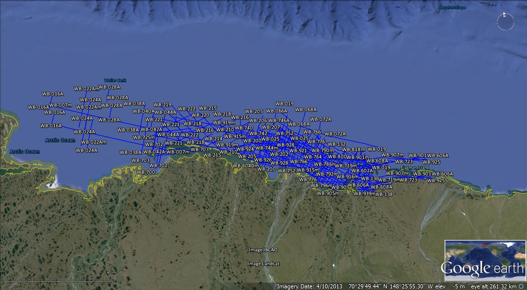
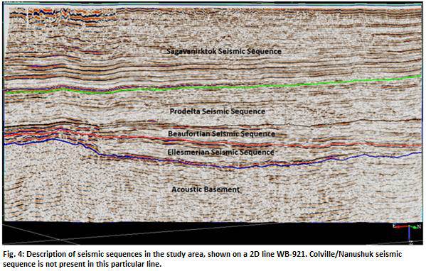
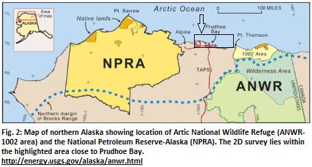
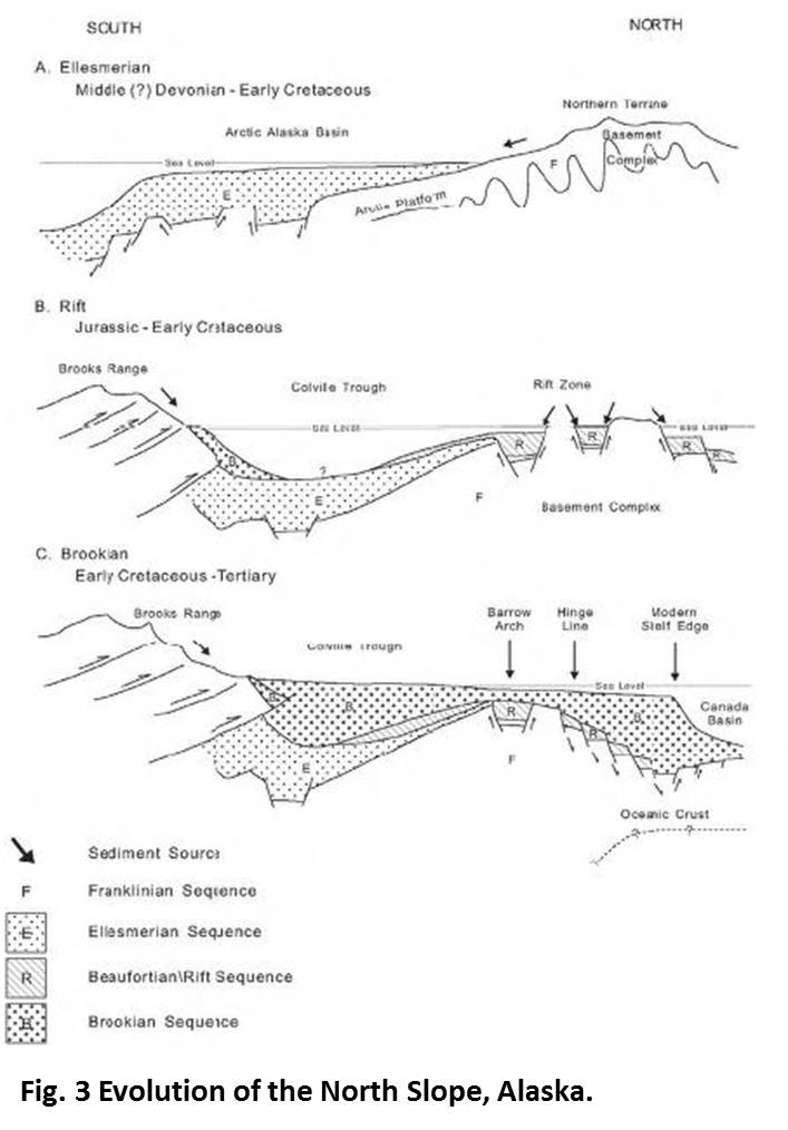
In the north of Alaska - just west of the Arctic National Wildlife Refuge (ANWR) and east of the National Petroleum Reserve- Alaska (NPRA) - lies the 59.500 km2 North Slope. The survey is situated in the shallow water of the Beaufort Sea continental shelf, adjacent to Alaska North Slope (Fig. 2). The Beaufort continental shelf is relatively narrow. For geological and logistical reasons, only the continental shelf is thought to have any realistic economic potential with respect to hydrocarbon accumulation. The Prudhoe Bay oil field lies close to the survey area. It is the largest oil field in North America, and it ranks among the world's top twenty largest oil fields. The geologic history of the area includes periods of plate collisions, continental rifting, regional uplift, episodes of major regional erosional scour, and sedimentary deposition. The Northern Alaska region has four major geologic sequences, each having a unique structural setting, provenance (sediment source area), and depositional environment. The four major sequences from the oldest to the youngest are: the Franklinian, Ellesmerian, Beaufortian Rift, and the Brookian. The older rocks are deposited first with an absence of structural complexities. The Ellesmerian sequence is the geologically most important because it contains petroleum reservoirs in Prudhoe Bay. The structural events that shaped the evolution of the North Slope Structural Province are highlighted in Fig. 3. This OpendTect survey contains two 2D seismic vintages (1977 and 1978). These vintages are loaded in one Lineset namely 2D-BeaufortSea-Shallow water. This data is taken from the National Data Archive of Marine Seismic Surveys maintained by USGS. Note that this is post-stack time-migrated seismic data. The polarity of the dataset is such that the compression is represented by trough or a negative number. The survey contains 119 seismic lines. Some of the seismic lines had various segments which required them to be merged. Hence, these lines have been merged and a suffix 'm' is added in the line name (for details see Table 1.1). Most of the 2D lines do not have a good tie at the intersections. Misties of up to '48ms' time shift were observed at these intersections. These misties were rectified by using the reference shift attribute of OpendTect. The majority of these misties were solved by applying a downward (increasing TWT time) shift. However, there were some cases when upward shift was applied. The misties varied with depth, meaning that a single bulk shift was insufficient to properly match the seismic lines through the whole depth and multiple shifts were required, matching various seismic reflectors (for details see appendix Table 1.2). The mistie-corrected original seismic 2D dataset is named PSTM_Corr. The seismic horizons in this study are: the top-of-acoustic-basement, top of Ellesmerian, top of Beaufortian, top of Prodelta, top of Colville/Nanushuk and the surface of Sea floor/top of Sagavenirktok (Fig. 4). |
References |
Available Data
2D Seismic: |
|
2D Horizons: |
|
3D Horizons: |
|
Wells: |
|
Please use an up to date version of Chrome, Firefox, Edge (on Windows) or Safari (on Mac) |


