Project Laurentian Basin - Complete
General
Country: | Canada |
Location: | Offshore, North Atlantic Ocean |
Blocks: | Laurentian Deep Rift Extensional Basin |
Coordinates: | N 45°04’24.82” / W 56°06’45.95′ |
Acquisition: | 1984 |
(Re)processing: | 2006 |
Value added Products: | 2018 |
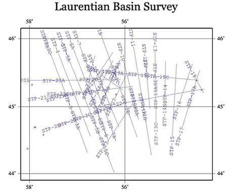
Data summary: | OpendTect project with Full stack 2D Data (29 lines) after applying a pre-stack time migration. |
Size: | 3.6 GB (uncompressed), 2 GB (download) |
License: | |
Download: |
|
Original seismic: | |
Value added products: | dGB Earth Sciences created the OpendTect project and computed attributes. |
|
|


Acknowledgment
Using the data and value-added products in this project in publications is permitted. We kindly request to be acknowledged in the following manner:
We thank dGB Earth Sciences for making the data available as an OpendTect project via their TerraNubis portal terranubis.com.
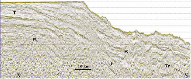
Line 20 example
Survey Parameters
Survey type: | Only 2D |
Inline range and step: | 9400, 15200, 1 |
Crossline range and step: | 10000, 14620, 1 |
Z range and step: | 0, 7, 0.004 Time |
Inline bin size (m/line): | 50 |
Crossline bin size (m/line): | 50 |
Area (sq km): | 67016.05 |
More InfoNOTE: Derived Attributes are released under the Creative Commons license but original seismic data is copyright of Department of Natural Resources Canada. All rights reserved. Distributed under the conditions specified in GEOGRATIS LICENCE AGREEMENT FOR UNRESTRICTED USE OF DIGITAL DATA, found at: Geological FeaturesExtensional and strike slip tectonics, salt tectonics, Mesozoic rifting, passive margin (late triassic-early jurassic), regional ‘base Cretaceous’ unconformity, seaward prograding Tertiary wedges, erosional features arising from the interplay of sea level changes with the St. Lawrence River; other features like channels, delta systems and canyons are also present, a good data for sequence stratigraphic interpretation. Full Survey Description
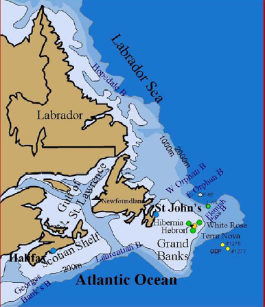
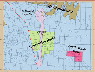
The Laurentian Basin covers an area of approximately 60,000 square km in shallow to deep water between the island of Newfoundland and province of Nova Scotia and the extensional strike slip domain of the Southern Grand Banks. A thick Mesozoic-Cenozoic succession (nearly 20km) downlaps onto oceanic crust to the south and onlaps the pre-rift Paleosozoic sediments on the basin’s northern flank. The basin shows a strong imprint of extensional and salt tectonics, similar to the Sable Sub-basin, from which oil, gas and condensate have been produced [2]. As petroleum exploration was restricted in the area until the recent resolution of international and inter-provincial boundary disputes, only one well has been drilled in the basin so far. This well (Bandol #1) was drilled in the French territory, and although no well report or logs have yet been released by the operators. It is reported in the media that it was a dry hole [1, 2]. In preliminary work based on a regional seismic grid, the Geological Survey of Canada (GSC) estimated that the basin could contain recoverable resources of 8–9 trillion cubic feet of natural gas and 600 to 700 million barrels of oil at an average expectation [1]. From a tectonic-stratigraphic point of view, the basin is located at the intersection of the Mesozoic Scotian Shelf extensional margin and the Southern GrandBanks extensional/strike slip margin, which dictates that elements of both systems will be observed in its structural style and stratigraphy. The basin’s petroleum systems includes the possibility of Mesozoic reservoirs being sourced by Paleozoic source rocks.
Basin Analogues: For play assessment of the deepwater slope it is necessary to employ information from worldwide analogues because at the time of the assessment there were no discoveries in deepwater depositional systems, only one dry well Bandol #1 in Laurentia Basin and three existing dry wells in the neighboring Nova Scotia deepwater slope (Shelburne G-29, Shubenacadie H-100 and Tantallon M-41) [3]. Hence, unlike the global analogues, proven petroleum systems on the Laurentia Slope remained unknown. The continental margin off Nova Scotia and Laurentia Basins have long been known as the definitive Atlantic-style passive margin; a pull-apart margin followed by thermal sag and a prograding shelf with a carbonate bank, major river delta system, and a mobile salt substrate. The three major analogue passive margins are all Atlantic facing, namely the Gulf of Mexico (GoM), offshore Brazil, and offshore West Central Africa, all which have enjoyed recent and continued deepwater success. |
References |
Available Data
Seismic: |
|
Please use an up to date version of Chrome, Firefox, Edge (on Windows) or Safari (on Mac) |